Delwedd:Anglo American War 1812 Locations map-en.svg

Y ffeil gwreiddiol (Ffeil SVG, maint mewn enw 1,052 × 744 picsel, maint y ffeil: 136 KB)
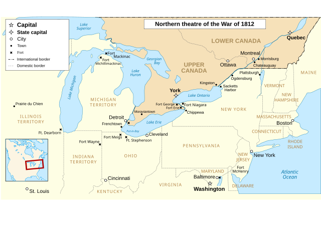
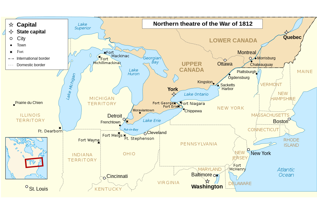
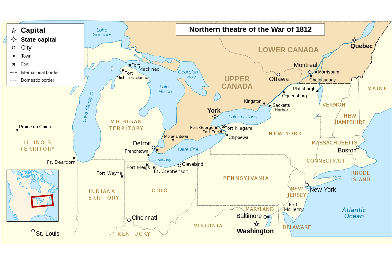
The map omits two of the most important battles of the war as far as the territorial outcome of the Treaty of Ghent. The Battle of Lake Erie (aka Battle of Put in Bay) was where the entire British Upper Great Lakes Fleet surrendered. With the Great Lakes supply lines cut, the British and their Indian allies destroyed the forts at Detroit and Amherstburg and tried to retreat up the Thames River hoping to reach the main British base at Burlington on Lake Ontario.The American army under General Harrison caught up with them at Moraviantown and the British were defeated. Most important was that Tecumseh was killed at this battle and, with his death, the Indian Confederation fell apart and thousands of the warriors just went home. When the Duke of Wellington, fresh from defeating Napoleon, was subsequently offered command of the British Army in America, he said he'd go but couldn't promise anything unless the Navy first got control of the Great Lakes. Otherwise, he told the negotiators that they may as well give up on any territorial demands and just make peace with the US. See "Three Strikes in the War of 1812".
| Disgrifiad |
English: Main locations of the War of 1812 between the United States and the United Kingdom Français : Principaux théâtres d'opérations de la Guerre de 1812 entre les États-Unis et le Royaume-Uni. Español: Principales teatros de operaciones de la Guerra de 1812 entre los Estados Unidos y el Reino Unido. |
| Dyddiad | (UTC) |
| Ffynhonnell | |
| Awdur |
|
| Diwygiadau eraill |
Derivative works of this file: |
| This is a retouched picture, which means that it has been digitally altered from its original version. Modifications: translated to english. The original can be viewed here: Anglo American War 1812 Locations map-fr.svg:
|
- Mae'n rhydd i chi:
- rhannu – gallwch gopïo, dosbarthu a throsglwyddo'r gwaith
- ailwampio – gallwch addasu'r gwaith
- Ar yr amodau canlynol:
- cydnabyddiaeth – Mae'n rhaid i chi nodi manylion y gwaith hwn, rhoi dolen i'r drwydded, a nodi os y bu golygu arni, yn y modd a benwyd gan yr awdur neu'r trwyddedwr (ond heb awgrymu o gwbl eu bod yn eich cymeradwyo chi na'ch defnydd o'r gwaith).
- rhannu ar dermau tebyg – Os byddwch yn addasu'r gwaith hwn, neu yn ei drawsnewid, neu yn adeiladu arno, mae'n rhaid i chi ddosbarthu'r gwaith dan drwydded sy'n union yr un fath same a'r gwreiddiol.

|
Caniateir copïo, dosbarthu a/neu golygu'r ddogfen hon yn ôl telerau'r Drwydded Ddogfennaeth Rydd GNU, Fersiwn 1.2 neu unrhyw fersiwn diweddarach a gyhoeddwyd gan y Free Software Foundation; yn cynnwys dim Adrannau Di-syfl, dim Testunau Clawr Blaen, a dim Testunau Clawr Cefn. Cynhwysir copi o'r drwydded hon yn yr adran Trwydded Ddogfennaeth Rydd GNU". |
Cofnod lòg yr uwchlwythiad gwreiddiol
This image is a derivative work of the following images:
- File:Anglo_American_War_1812_Locations_map-fr.svg licensed with Cc-by-sa-3.0,2.5,2.0,1.0, GFDL
- 2008-06-20T23:26:18Z MaCRoEco 1494x830 (154198 Bytes) {{Information |Description= |Source= |Date= |Author= |Permission= |other_versions= }}
- 2008-06-17T16:04:43Z Sémhur 1494x830 (163461 Bytes) Mistake : Fort Henry => Fort McHenry
- 2008-06-17T09:50:41Z Sémhur 1494x830 (163245 Bytes) {{Information |Description={{en|1=Main locations of the [[:en:War of 1812|War of 1812]] between the United States and the United Kingdom}} {{fr|1=Principaux théâtres d'opérations de la [[:fr:Guerre de 1812|Guerre de 1812]]
Uploaded with derivativeFX
Hanes y ffeil
Cliciwch ar ddyddiad / amser i weld y ffeil fel ag yr oedd bryd hynny.
| Dyddiad / Amser | Bawdlun | Hyd a lled | Defnyddiwr | Sylw | |
|---|---|---|---|---|---|
| cyfredol | 01:52, 6 Mawrth 2023 | | 1,052 × 744 (136 KB) | wikimediacommons>Hunter9502 | Reverted to version as of 08:55, 7 February 2021 (UTC) - February 2023 version has broken SVG formatting |
Defnydd y ffeil
Mae'r 1 tudalennau a ddefnyddir isod yn cysylltu i'r ddelwedd hon: